
Key Takeaways
- Construction staking translates a project's engineering plans into physical reference points on the ground so contractors can build exactly what was designed.
- Accurate staking prevents costly rework — a staking error of even a few tenths of a foot can shift a slab, misalign utilities, or violate a setback.
- In Lafayette and Acadiana, modern crews use RTK GNSS and robotic total stations to achieve horizontal accuracy of roughly 0.05 feet on most residential and commercial sites.
- Rough grade, fine grade, and as-built stakes are placed at different project phases — each has a distinct purpose and tolerance.
What Is Construction Staking?
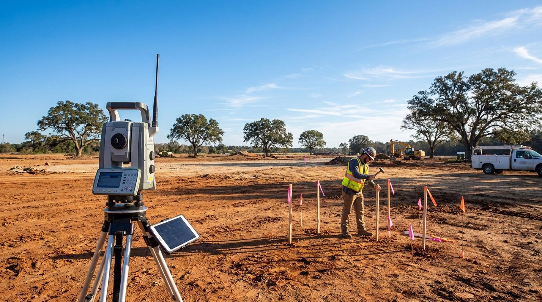
Construction staking is the process of placing wooden stakes, lath, or hubs in precise locations on a job site to guide contractors as they build. A licensed land surveyor reads the project's engineered plans — site plans, grading plans, and utility drawings — and transfers those coordinates to the ground using survey-grade equipment. Each stake tells a builder where a wall, curb, pipe, or slope change should go, and often how much to cut or fill to reach design elevation.
Sometimes called "construction layout," staking is the bridge between the engineer's drawing and the contractor's build. Without it, excavators, concrete crews, and utility installers would be guessing at dimensions, and every trade would have to reconcile its own interpretation of the plans. A good staking package makes the site "ready to build" — every major feature is marked, elevations are flagged, and offsets are documented so the markers can be replaced if equipment destroys them.
For projects in Lafayette Parish and across South Louisiana, construction staking is typically performed by a Louisiana-licensed Professional Land Surveyor or under their direct supervision, consistent with state licensing rules.
Why Accurate Construction Staking Matters in Lafayette
Accurate staking protects the project's schedule, budget, and legal standing. When stakes are set precisely, contractors can pour foundations, run utilities, and grade pads with confidence that everything will tie together and meet the approved plans. When stakes are off, the cost of correction is almost always higher than the cost of doing it right the first time.
Consider a typical commercial slab in Broussard or Youngsville. If the building corners are staked two-tenths of a foot out of position, the slab may encroach on a setback, clip a utility easement, or throw off the geometry of an attached canopy. Fixing that after concrete is placed can mean saw-cutting, partial demolition, or a variance request — sometimes all three. Staking errors on utility runs are even worse, because a misaligned sewer lateral or water service often isn't discovered until tie-in, long after the trench is backfilled.
Lafayette's soils add another layer. Much of Acadiana sits on soft, saturated clays and silts that shift with moisture. Stakes set in wet ground heave and settle, and site traffic knocks them over constantly. Experienced surveyors plan for this by setting offset hubs outside the work zone, referencing permanent control points, and re-staking as phases progress rather than trying to set everything up front.
The Construction Staking Process, Step by Step
A typical staking workflow moves through a series of defined phases that correspond to the contractor's schedule. Each phase has its own deliverables, tolerances, and stake conventions so the builder knows at a glance what a marker represents.
1. Control and Boundary Verification
Before any feature is staked, the surveyor establishes horizontal and vertical control on the site. This usually means setting two or more permanent control points tied to the state plane coordinate system (Louisiana South Zone) and a benchmark tied to NAVD88. Boundary corners are checked against the record plat so that every stake downstream is referenced to the correct property limits.
2. Clearing and Rough Grade Staking
Rough grade stakes mark the limits of disturbance, pad corners, and preliminary cut/fill quantities. Tolerances at this phase are looser — typically 0.1 to 0.2 feet — because material will still be moved. Blue-top stakes, lath with ribbon, and offset hubs are common.
3. Building Corner and Slab Staking
Once the pad is graded, the surveyor stakes building corners, column lines, and slab edges with tighter tolerances, often 0.02 to 0.05 feet. For residential construction, this is the form survey phase, where the forms themselves are checked before concrete is poured.
4. Utility Staking
Storm, sanitary, water, gas, and electrical lines each get their own stakes. Inverts and rim elevations are cut or filled to the stake, and manholes and structures are located precisely so that future tie-ins hit their design coordinates.
5. Curb, Pavement, and Fine Grade Staking
Blue-top stakes are set to finished grade for pavement subgrade, and curb stakes mark horizontal and vertical control for concrete work.
6. As-Built Survey
After construction, the surveyor returns to locate what was actually built. As-built data supports record drawings, utility coordination, and, when needed, FEMA elevation certificates or LOMA submissions.
Technology Behind Modern Construction Staking
Modern staking crews in Lafayette rely on two primary tools: RTK GNSS receivers and robotic total stations. Together they deliver survey-grade accuracy faster than the transit-and-tape methods of a generation ago.
RTK GNSS uses satellite signals corrected by a local base station or a statewide network like LSU's GULFNet. A single surveyor with a rover pole can locate or set a stake in seconds, typically to 0.03 to 0.05 feet horizontally and about 0.1 feet vertically under open sky. RTK shines on large pads, parking lots, and linear projects where a clear view of the sky is available.
Robotic total stations handle the detail work — building corners, column lines, anchor bolts, and anywhere trees, canopies, or structures block the sky. A robotic instrument automatically tracks the prism pole, allowing a one-person crew to work quickly at millimeter-level precision.
Data flows both ways. The engineer's CAD file is loaded into a field controller, and every point the crew sets in the dirt is logged back into the same coordinate system. That tight digital workflow is what allows modern surveying services to deliver same-day corrections when the design changes, which it almost always does.
Drone photogrammetry and terrestrial laser scanning add a third layer for complex sites. A quick drone flight before earthwork captures existing conditions in detail, and scans of complex structures ensure tie-ins to existing construction are accurate.
What to Expect When You Hire a Surveyor for Construction Staking
A well-run staking engagement starts with a clear scope. The surveyor will ask for the latest approved civil plans, a recent boundary survey if one exists, and the contractor's schedule. From that they build a staking package that lists every deliverable — pad stakes, building corners, utilities, curbs — along with the expected accuracy for each.
Expect some re-staking. Even on well-run sites, heavy equipment destroys markers, and it's normal to pay for a stake-out two or three times over the course of a project. Budgeting for that upfront is cheaper than pausing work to wait for the surveyor. On a typical Lafayette residential or small commercial job, staking is often billed in phases or as a lump sum with documented re-stake rates.
Pioneer Surveying serves projects throughout Lafayette, Broussard, Youngsville, Scott, Carencro, Opelousas, and the broader Acadiana region, and works directly with contractors and developers on schedules that shift in real time. If you're planning a build and want a staking partner who can keep up with the job, call us at (337) 443-0955 or reach out through our contact page to scope the work.
Frequently Asked Questions
What is construction staking and why is it important?
Construction staking is the process of placing physical markers on a job site that correspond to locations on the engineered plans. It's important because contractors rely on those stakes to build walls, slabs, utilities, and pavement in exactly the right place. Without accurate staking, projects risk setback violations, utility misalignment, and expensive rework.
How accurate is construction staking in Louisiana?
Modern construction staking in Louisiana typically achieves horizontal accuracy of about 0.02 to 0.05 feet on building corners and around 0.1 feet or better on rough grade work. Those tolerances are routinely met with RTK GNSS and robotic total stations, both referenced to the Louisiana South State Plane coordinate system and NAVD88 vertical datum.
Who is qualified to perform construction staking in Lafayette, LA?
In Louisiana, construction staking must be performed by a licensed Professional Land Surveyor or by crews working under their direct supervision. Licensing is administered by the Louisiana Professional Engineering and Land Surveying Board. Hiring a licensed surveyor ensures the work meets state standards and holds up if a project is later audited or disputed.
How much does construction staking cost in Lafayette Louisiana?
Construction staking costs in Lafayette vary with project size, complexity, and the number of staking phases. A small residential slab stake-out is typically a few hundred dollars, while a multi-acre commercial site with utilities, curbs, and multiple re-stakes can run into the thousands. Most surveyors price staking in phases so owners pay for rough grade, building corners, utilities, and fine grade separately.
How often do stakes need to be replaced during construction?
Stakes are commonly destroyed by equipment, trenching, and weather, so it's normal for the surveyor to return and re-stake as a project progresses. On an active Lafayette site, expect at least one re-stake per major phase — rough grade, building corners, utilities, and fine grade. Planning and budgeting for re-stakes upfront prevents schedule delays when a work front stops because markers are gone.