
Key Takeaways
- A FEMA Letter of Map Amendment (LOMA) can remove your property from a high-risk flood zone, potentially saving you thousands in annual flood insurance premiums.
- Properties in Lafayette and Acadiana are frequently misclassified due to outdated flood maps — a professional elevation survey can prove your home sits above the Base Flood Elevation.
- The LOMA application process is free through FEMA, but requires an Elevation Certificate prepared by a licensed surveyor.
- Most LOMA requests in South Louisiana are processed within 60 days when submitted with accurate survey data.
What Is a FEMA Letter of Map Amendment?
A FEMA Letter of Map Amendment is an official determination that removes a specific property from a high-risk flood zone on FEMA's Flood Insurance Rate Map (FIRM). When FEMA issues a LOMA, it formally recognizes that your property was incorrectly included in a Special Flood Hazard Area (SFHA) — typically a Zone A or Zone AE designation — because the structure or lot actually sits above the Base Flood Elevation (BFE).
This distinction matters because properties inside an SFHA are required to carry flood insurance if they have a federally backed mortgage. That insurance can cost anywhere from � to over \,000 per year in Lafayette Parish, depending on the property's characteristics. A successful LOMA application eliminates that mandatory requirement, potentially saving homeowners tens of thousands of dollars over the life of a mortgage.
It's important to understand that a LOMA doesn't change the flood map itself. It's a property-specific amendment that stays on record with FEMA. If you sell the property, the LOMA transfers with it, protecting future owners as well.
Why Flood Zone Designations Matter in Lafayette
Lafayette and the surrounding Acadiana region face unique flood zone challenges that make LOMAs especially relevant to local property owners. FEMA's flood maps for Lafayette Parish were last substantially updated in recent years, but they still rely on modeling that doesn't always account for localized grading, fill work, or elevation changes from recent development.
Many properties in neighborhoods across Broussard, Youngsville, and Lafayette proper were built on lots that were filled and graded above the BFE before construction. Despite this, the FEMA map may still show the entire subdivision or area as Zone AE simply because the broader topography fits that designation. The result is that homeowners pay for mandatory flood insurance on properties that don't actually face high flood risk.
South Louisiana's flat terrain and extensive drainage systems compound this issue. Elevation differences of just one or two feet — which are common after site preparation and construction — can mean the difference between being inside or outside a flood zone. Without an accurate survey to document that elevation, FEMA's broad-stroke mapping controls your insurance requirements.
After the devastating floods of 2016, FEMA remapped many areas of Lafayette Parish. Some properties that were previously outside flood zones were reclassified into them. Property owners who had fill added during construction or whose homes were built at higher elevations may now be paying for insurance they don't legally need — if they can prove their elevation with a LOMA.
Who Qualifies for a LOMA?
A property qualifies for a LOMA when its lowest point (for a lot) or lowest adjacent grade (for a structure) is at or above the Base Flood Elevation for its location. This is a straightforward elevation comparison: if your property sits high enough, FEMA will remove it from the flood zone.
There are two types of LOMA determinations:
- LOMA for the structure only: FEMA determines that the building's lowest adjacent grade is at or above the BFE. The structure is removed from the SFHA, but the lot may remain partially in the flood zone.
- LOMA for the entire property: FEMA determines that the lowest point of the entire lot is at or above the BFE. Both the structure and land are removed from the SFHA.
In many cases across Lafayette Parish, properties qualify because builders added fill dirt to raise the building pad before construction. The original FEMA map was drawn based on natural ground elevations, so once a property is built up and graded, the actual elevation may exceed the BFE by a comfortable margin.
Properties that were built below the BFE, or in areas where the flooding risk is genuinely present, won't qualify for a LOMA. The process is specifically designed for properties that were incorrectly mapped — not for reducing insurance costs on properties that truly face flood risk.
The LOMA Application Process Step by Step
Filing a LOMA application with FEMA is free and relatively straightforward when you have the right documentation. The process typically takes 30 to 60 days from submission to determination. Here's what's involved:
1. Obtain an Elevation Certificate
The most critical piece of the LOMA application is an Elevation Certificate (FEMA Form 086-0-33). This document must be prepared by a licensed professional land surveyor and provides the precise elevation measurements FEMA needs to make its determination. The surveyor will measure the property's lowest adjacent grade, the elevation of the lowest floor, and the location relative to the FIRM.
2. Gather Supporting Documents
You'll need a copy of your property's FEMA Flood Insurance Rate Map panel showing the flood zone designation, a community number and map panel number (your surveyor or local floodplain administrator can help with these), and the property's legal description or tax parcel information.
3. Submit the MT-1 Application
FEMA's online LOMC (Letter of Map Change) system accepts applications through their eLOMA portal for straightforward cases, or through the standard MT-1 application form for more complex situations. A licensed surveyor can often submit eLOMA applications directly, which speeds up the process significantly.
4. FEMA Review and Determination
FEMA reviews the elevation data against the BFE for your location. If the numbers support removal from the flood zone, FEMA issues the LOMA, typically within 30 to 60 days. If additional information is needed, FEMA will contact the applicant with specific requests.
5. Notify Your Insurance Company and Lender
Once you receive the LOMA, provide a copy to your mortgage lender and flood insurance provider. Your lender is required to remove the mandatory flood insurance requirement, and you can cancel your policy or reduce it to a preferred-risk option if you choose to maintain coverage voluntarily.
How a Professional Surveyor Helps with Your LOMA
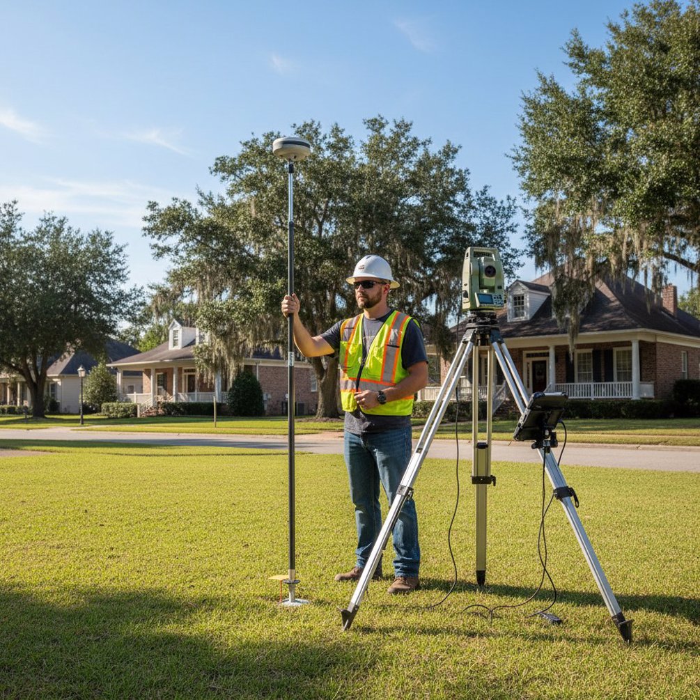
The entire LOMA process hinges on accurate elevation data, which makes choosing the right surveyor the most important decision in the process. A licensed professional land surveyor with experience in flood zone work will use RTK GNSS receivers and robotic total stations to capture precise elevation measurements referenced to the NAVD88 datum that FEMA requires.
At Pioneer Surveying, LOMA-related elevation work is a regular part of our surveying services throughout Lafayette Parish and the broader Acadiana region. An experienced surveyor doesn't just take measurements — they understand how to interpret FEMA's mapping data, identify which BFE applies to your specific location, and determine whether your property qualifies before you invest time in the application process.
The difference between a surveyor who routinely handles FEMA work and one who doesn't can mean the difference between a smooth approval and a rejected application. Surveyors familiar with Lafayette's flood zones know the common problem areas, understand the local drainage patterns, and can advise you honestly about your property's chances of qualifying.
If you're unsure whether your property qualifies for a LOMA, or if you've been told you need flood insurance and want to explore your options, contact Pioneer Surveying at (337) 443-0955 for a consultation. An initial review of your property's location on the FIRM can often tell us whether pursuing a LOMA is worthwhile before any field work begins.
Frequently Asked Questions
How much does it cost to get a LOMA in Lafayette, LA?
Filing a LOMA application with FEMA is free. The primary cost is the Elevation Certificate, which requires a licensed land surveyor to visit your property and take precise measurements. In the Lafayette area, elevation certificates typically cost between � and � depending on the property's size and accessibility. Given that flood insurance can run \,000 to \,000 or more annually, the survey often pays for itself within the first year.
How long does the FEMA LOMA process take?
Once submitted with complete and accurate documentation, FEMA typically processes LOMA requests within 30 to 60 days. The eLOMA system, which allows surveyors to submit straightforward cases electronically, can sometimes produce determinations in as little as a few days. The overall timeline depends on getting the elevation certificate completed first, which usually takes one to two weeks to schedule and deliver.
Do I need a survey before applying for a LOMA?
Yes. A FEMA Elevation Certificate prepared by a licensed professional land surveyor is required for all LOMA applications. This certificate documents your property's elevation relative to the Base Flood Elevation and provides the technical data FEMA needs to make its determination. Without an accurate elevation certificate, FEMA cannot process your application.
What happens if FEMA denies my LOMA application?
If FEMA denies your LOMA, it means your property's elevation does not meet the threshold for removal from the flood zone. You still have options: you can request a Letter of Map Revision Based on Fill (LOMR-F) if you plan to add fill to raise the property's elevation, or you can explore preferred-risk flood insurance policies that offer lower premiums. Your surveyor can advise you on whether additional site work could make your property eligible in the future.